| HOME |
 |
 |
|
|
||||||||
 |
|||||||||||||||||||||||
| |||||||||||||||||||||||
| Earth
Institute News
Contact: Columbia University Researcher Develops New
Use For Seismic Reflection Data: Revealing Locations And Potentials
For Mega Earthquakes
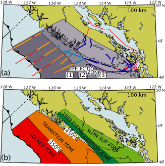
Mladen Nedimovic, the lead author and a scientist at the Lamont-Doherty Earth Observatory, a member of the Earth Institute at Columbia University, examined reflection data collected on the northern Cascadia margin off the coast of Vancouver Island. Cascadia margin is an area where the north Pacific seafloor is being pushed under the continental margin of North America. Locations where oceanic plates are underthrusting the continents are known as subduction zones. Within subduction zones are enormous faults called megathrusts, the places where the two tectonic plates meet and interface one another. Megathrusts are the source of the largest and most devastating earthquakes on Earth. From the reflection data, Nedimovic and his coauthors mapped the locked zone on the megathrust along the northern Cascadia margin, which hosts the populous cities of Vancouver and Seattle. Locked zones, where geological structures beneath the surface are tightly interfaced, build up enormous pressure as the Earth shifts. In 1700, the pressure beneath the Cascadia margin was released, resulting in a magnitude 9 earthquake that devastated the region. A magnitude 9 earthquake releases over 1000 times more energy than was released during the magnitude 6.8 Nisqually earthquake that shook Seattle two years ago. Currently, dislocation and thermal modeling are used for mapping locked zones, however, both methods rely on many assumptions about Earth’s structure that may limit their accuracy. In fact, for the northern Cascadia margin, estimates of the locked zone using these techniques indicate that a 36-mile (~60 km) swath of land from the subduction trench toward Vancouver Island is locked. Nedimovic’s reflection analysis shows that it is more likely to be a 56-mile (~90 km) swath, extending the zone some 20 miles (~30 km) closer to land. If this is accurate, rapidly growing inland cities face a greater threat from megathrust earthquake hazards than previously anticipated. The occurrence rate for great earthquakes on the Cascadia megathrust is approximately every 200 to 800 years. We are currently within the timeframe where another large earthquake is expected, with the last earthquake having occurred over 300 years ago. Seismic and aseismic slip occurs on different parts of a megathrust, at different depths, temperatures, and pressures, and due to different types of rock deformation. Brittle rock failure affects a narrow zone around the thrust where seismic slip is observed, and plastic deformation affects a much wider area above the thrust where the slip is slow and aseismic. Seismic reflection imaging reveals the variations in structures along the megathrust and can be used for detailed mapping of locked and slow-slipping zones. “Deep seismic reflection images from Alaska, Chile, and Japan show a similar broad reflection band above the megathrust in the region of stable sliding and thin thrust reflections further seaward where the megathrust is locked, suggesting that reflection imaging may be a globally important predictive tool for determining the maximum expected rupture area in great subduction earthquakes,” said Nedimovic. “Mega earthquakes have been instrumentally recorded for all three regions making them potential targets for a future investigation to confirm the reflection method and improve characterization of megathrust seismic hazards in the study area.” The northern Cascadia margin study was funded by the National Earthquake Hazards Reduction Program of the United States Geological Survey and by the Geological Survey of Canada. Mladen Nedimovic and his collaborators are submitting a proposal to National Science Foundation to carry out a megathrust seismic hazards characterization study along the southern Alaska margin.
KEY The Lamont-Doherty Earth Observatory, a member of The Earth Institute at Columbia University, is one of the world’s leading research centers examining the planet from its core to its atmosphere, across every continent and every ocean. From global climate change to earthquakes, volcanoes, environmental hazards and beyond, Observatory scientists provide the basic knowledge of Earth systems needed to inform the future health and habitability of our planet. For more information, visit www.ldeo.columbia.edu. The Earth Institute at Columbia University is the world’s leading academic center for the integrated study of Earth, its environment, and society. The Earth Institute builds upon excellence in the core disciplines—Earth sciences, biological sciences, engineering sciences, social sciences and health sciences—and stresses cross-disciplinary approaches to complex problems. Through its research training and global partnerships, it mobilizes science and technology to advance sustainable development, while placing special emphasis on the needs of the world’s poor. For more information please see www.earth.columbia.edu. |
|||
|