Project 3: OBWAVE: Orphan Basin Wide-Angle Velocity Experiment
Project 3: OBWAVE: Orphan Basin Wide-Angle Velocity Experiment
In collaboration with our industry partners
Funded by ExxonMobil and ConocoPhillips
The Orphan Basin is a large, deep water basin located north of the Grand Banks and northwest of Flemish Cap (Figure 1). It is one of the largest rift basins to have undergone hyper-extension without continental breakup and seafloor spreading. Gravity modelling shows that the extended crust might be as thin as 5 km in the thinnest areas of the basin. Such a setting allows detailed imaging of a cross section of a complete continental crustal extension system along a single profile. Several industry boreholes exist within the deep-water basin and the extensional structures also connect to wells within Flemish Pass and the petroleum prolific Jeanne d’Arc Basin to the south.
Previous studies show that Orphan Basin is divided into eastern and western sub-basins by a series of faults and high relief basement ridges (Figure 1). Within each sub-basin, there are series of smaller ridges and troughs trending N-S in the west to NE-SW in the east, which formed during Mesozoic rifting between N. America and Africa/Europe and the rotation of Flemish Cap (FC) to the southeast. An older Lithoprobe MCS profile and a more recent grid of extensive industrial MCS profiles have provided detailed images of these structures. However, the link between basement structures with underlying crustal layers and Moho depths remains uncertain. The only basin-wide wide-angle seismic profile used to constrain deeper crustal structure crossed the basement structures at an oblique angle and had wide spacing (~10-50 km) between the OBS that limited the resolution of the velocity model.
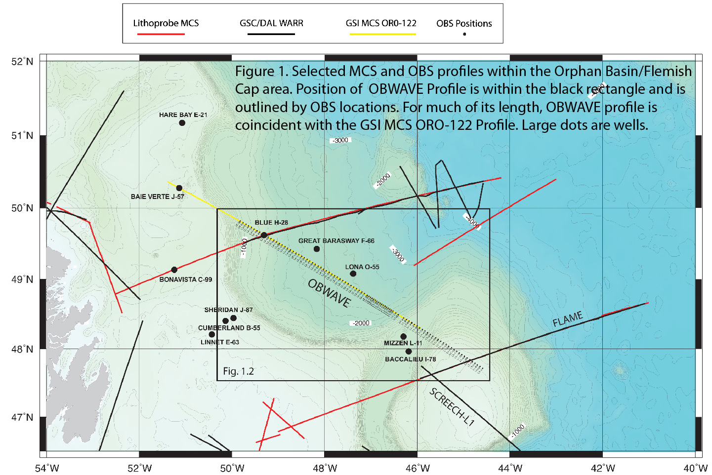
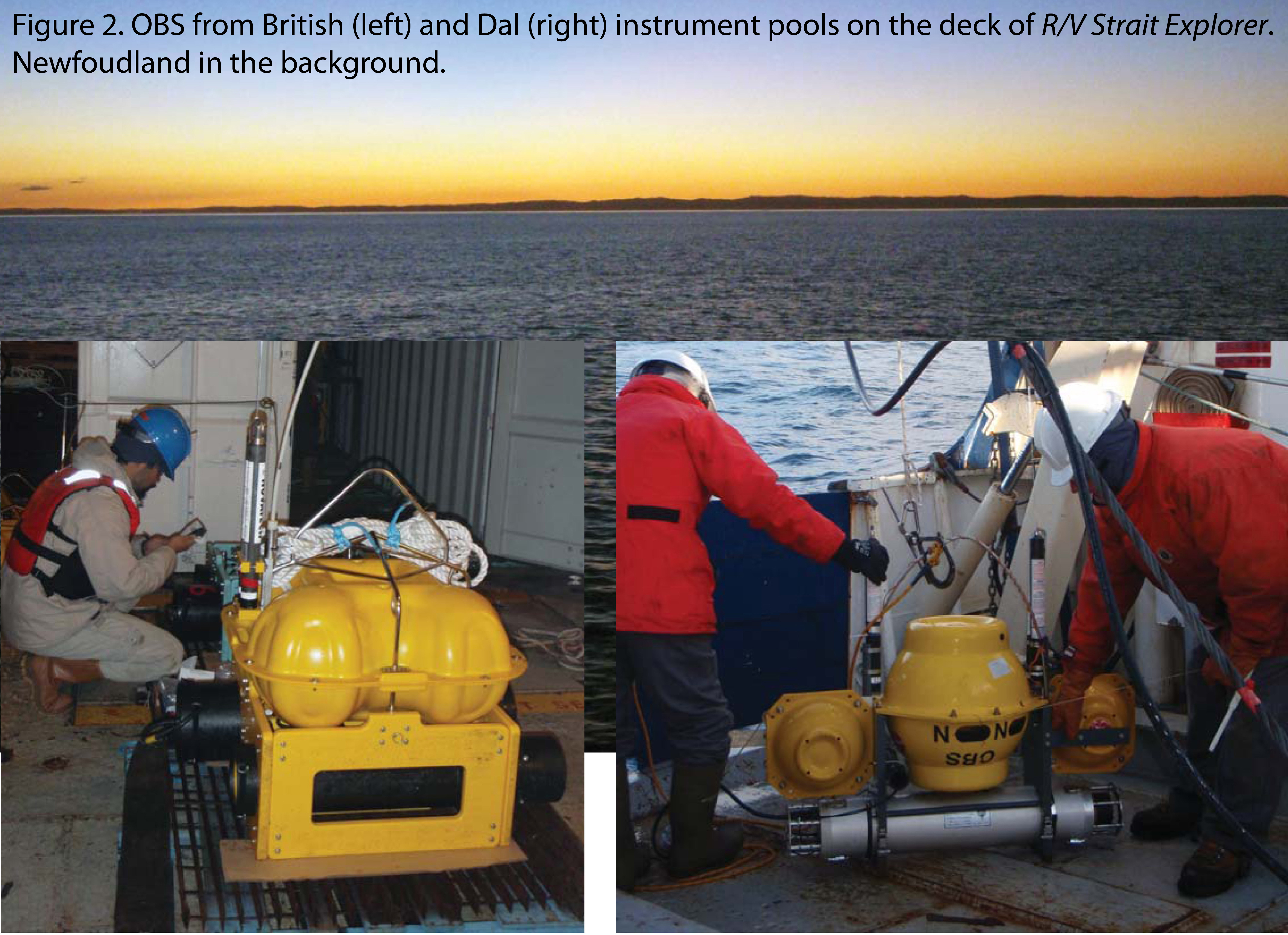
In order to improve imaging of crustal structures, high resolution wide-angle data were acquired in 2010 during the OBWAVE (Orphan Basin Wide Angle Velocity Experiment) project (Figure 2) with financial backing from ExxonMobil. The refraction line (Figure 1) stretches along a NW-SE profile from Flemish Cap across the eastern sub-basin and into the western sub-basin. The profile is coincident with MCS profile OR0-122, previously acquired by GSI. Usable 4-component OBS data were collected at 89 receiver stations with 3-5 km spacing along a 500-km-long profile. An airgun array, consisting of 3 clusters of 3 G-guns (total volume of 4680 cu. in.), was fired every 60 s for an average shot spacing of 140 m. The western half of the profile was double-shot to increase fold.
The first phase of the data analysis was carried out with financial support from ExxonMobil. First arrivals and wide-angle Moho reflections (PmP) were picked from common receiver gathers. Tomographic inversion for the first arrival picks and PmP arrivals was ran using the Tomo2D algorithm. The traveltime tomograpy results, published in Geophysics (Watremez et al., 2015), are of remarkably high resolution and show that dense regional OBS deployments at extensional basins have the potential to image the crustal structures with details that cannot be observed with coarser OBS deployments that have been used routinely for regional crustal investigations of rifting. For the Orphan Basin study, increased velocity image resolution was particularly useful to delineate the tilted blocks, top of the crystalline basement, and capture the extreme thinning of the continental crust. Traveltime tomogrpahy was followed by picking of secondary arrivals and layered velocity modeling using RAYINVR software. Detailed interpretation based on the results of the layered velocity modeling was published in Geophysical Journal International (Lau et al., 2015). We teamed up with reserachers from the University of Western Ontario for the second phase of data analysis that encompasses running full waveform inversion. We expect that the results from this work will be publised in 2018-2019.