
Earth Institute News
posted 01/24/05
Contact: Mariellen Gallagher
212-854-2583 or mg1152@columbia.edu
LDEO Marine Seismic Research Contributes to Global Tsunami Detection and Warning System
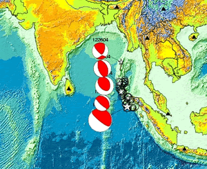
LDEO scientists plotted the Mw 9.0 earthquake that took place on 12/26/04. Image Credit: Dr. Won-Young Kim, senior research scientist at LDEO
Marine seismic research will play an invaluable role in providing the same level of warning currently in the Pacific Ocean to the Indian and Atlantic Oceans, including the Caribbean Sea and Gulf of Mexico. In January 2005 the Bush Administration committed $37.5 million to expand the current global tsunami detection and warning systems.
“Marine seismic research is critical in identifying potential sources of tsunami,” said Dr. Arthur Lerner-Lam, a seismologist at the Lamont-Doherty Earth Observatory (LDEO). In addition to characterizing tsunamigenic faults, including identifying the segments most likely to rupture in great earthquakes, marine seismic techniques can be used to map accurately the near-shore underwater levels and other measurements, so that tsunami wave heights can be accurately predicted when warnings are issued.
“It is even possible to use very high-resolution seismic images to identify prehistoric earthquake ruptures and landslides that have no instrumental or human record,” said Lerner-Lam. “These observations help scientists calculate the average interval between tsunami-causing events, a factor in measuring risk. Taken together, marine seismic observations allow managers of tsunami warning systems to prioritize the installation of earthquake and tsunami sensors and to recognize the tsunami-generating potential of big events as soon as they occur, in time to issue warnings.”
The oceanographic research vessel, Maurice Ewing, owned by the National Science Foundation and operated by LDEO, is the only academic ship devoted to obtaining images of deep earth for fundamental earth science research. Last year, researchers on the Ewing collected geophysical data along the southeast Caribbean plate boundary that separates the Caribbean Sea and South America. This extensive fault system is capable of unleashing earthquakes of significant magnitude. In 1997, a magnitude 6.9 earthquake near Cariaco, Venezuela killed dozens of people.
“Our work to assess earthquake potential on the Ewing is contributing to a greater understanding of earthquake hazards along the coast of Venezuela and in the Netherlands Antilles Islands in the southeast Caribbean Sea. We know that the southeast Caribbean margin is about the same length and has the same total displacement as the San Andreas fault in California,” said Professor Alan Levander, a geophysicist at Rice University and leader of this project.
Additionally, using data collected from this project and a wide variety of other data, Levander and colleagues will estimate tsunami potential in the Caribbean.
The images generated from marine seismic research provide information about earth’s active processes, such as the recent earthquake and tsunami in the Indian Ocean. Many of the earth’s systems, such as earthquakes, occur deep within the crust, many miles beneath the ocean floor. The only way to ‘look’ at craters, faults and other underwater structures is with the use of sound waves. Sound waves are reflected back from the target, allowing researchers to determine, for example, precisely where the earthquake faults are located, where undersea volcanoes are likely to erupt, and where hydrothermal vent systems are operating, among other things.
Using deep seismic imaging techniques, Dr. Mladen Nedimovic, a geophysicist at LDEO, and his collaborators have found a new means to more accurately predict the locations and potential for megathrust earthquakes. Nedimovic examined reflection data, commonly used to image geological structures, collected on the northern Cascadia margin, an area which hosts the populous cities of Vancouver and Seattle and where the north Pacific seafloor is being pushed under the continental margin of North America. Locations where oceanic plates underthrust the continents are known as subduction zones. Within subduction zones are enormous faults called megathrusts, the places where the two tectonic plates meet and interface one another. Megathrusts are the source of the largest and most devastating earthquakes on earth, such as the recent earthquake in the Indian Ocean off the coast of Sumatra.
Nedimovic, commenting on past seismic activity in the Cascadian margin, said, “In 1700, the pressure beneath the Cascadian margin was released, resulting in a magnitude 9 earthquake that devastated the region. The December 26, 2004 Indian Ocean earthquake was also a magnitude 9 event. Megathrust earthquakes that are even larger than magnitude 9 have been recorded during this century along the Alaska-Aleutian subduction zone.
Currently scientists are on the research vessel Ewing to collect data near the Yucatan Peninsula in the Gulf of Mexico in order to understand better the global environmental consequences of large diameter meteor impacts such as the Chicxulub event, which occurred sixty-five million years ago when a massive meteorite crashed into the Yucantan Penninsula leaving behind the 195 kilometer-wide Chicxulub crater.
“The Chicxulub crater is the smoking gun for the mass extinction of species marking the end of the Cretaceous (K) period and the start of the Tertiary (T) period. This research will improve our current understanding of how such an impact can cause worldwide mass extinctions. Our planet has been bombarded by meteor impacts throughout history, including the 20th century, and our research results will help to explain the dynamics and repercussions of meteor impacts, “ added Gail Christeson, a scientist at the University of Texas involved in the project. "In addition, the groundwater supply of the Yucatan appears to be largely controlled by the shape of the underlying crater, so our study is of importance to the local inhabitants of the area. Dr. Mario Rebolledo-Vieyra of the Centro de Investigación Científica de Yucatán is assisting us in the project."
Researchers of the Instituto Geofisica of the Universidad Nacional Autonoma de Mexico (UNAM) and the Universities of Cambridge and London in the United Kingdom are supporting the project team.
The earthquake and resultant tsunami that devastated coastal areas throughout the Indian Ocean on December 26 provides a tragic but illustrative example of the importance of marine seismic research in helping us to better understand earth’s active processes and improve our ability to define risks associated with major earthquakes, tsunamis, volcanoes, landslides and climate change. The December 26 Sumatra-Andaman Island earthquake occurred on the Java Trench (use figure), a known tectonic plate boundary separating the Indian Plate from the Burma Plate, and registered 9.0 magnitude, making it the fourth strongest this century. The resulting tsunami reached the shore of Sumatra within minutes and then fanned out across the Bay of Bengal, reaching the shorelines of Thailand, Myanmar, Bangladesh, India, Sri Lanka and the Maldives within the next three hours. The death toll from these events is now well over 200,000.
The Lamont-Doherty Earth Observatory, a member of The Earth Institute at Columbia University, is one of the world's leading research centers seeking fundamental knowledge about the origin, evolution and future of the natural world. More than 200 research scientists study the planet from its deepest interior to the outer reaches of its atmosphere, on every continent and in every ocean. From global climate change to earthquakes, volcanoes, nonrenewable resources, environmental hazards and beyond, Observatory scientists provide a rational basis for the difficult choices facing humankind in the planet's stewardship. For more information, visit www.ldeo.columbia.edu.
The Earth Institute at Columbia University is the world’s leading academic center for the integrated study of Earth, its environment and society. The Earth Institute builds upon excellence in the core disciplines—earth sciences, biological sciences, engineering sciences, social sciences and health sciences—and stresses cross-disciplinary approaches to complex problems. Through research, training and global partnerships, it mobilizes science and technology to advance sustainable development, while placing special emphasis on the needs of the world’s poor. For more information, visit www.earth.columbia.edu.